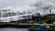
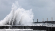
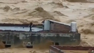
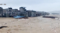
【新唐人2013年04月26日訊】據中國地震局網站消息,截至24號14點30分,四川省雅安蘆山「4.20」7級強烈地震,共計造成196人死亡,失蹤21人,11470人受傷,1992894人受災,住房倒塌14萬多間,嚴重受損36萬多間,622座水庫、208座水電站受損。有學者分析,這場大災難與時任四川省委書記周永康大搞西部大開發——興建水庫有關。請看報導。
關於雅安地震的原因,目前專家學者的看法不一。對於蘆山周圍水庫和大型水電站集中,是否是誘發地震的原因﹖四川省地礦局區域地質調查隊工程師範曉向媒體表示,不完全排除這種可能性。
而2008年汶川地震以來,地質專家研究發現,「紫坪舖水庫」與汶川地震有著密切的關係。範曉表示,據他勘測,這次雅安地震是2008年汶川地震的餘震,而非獨立的地震。
旅居德國的中國環境、國土問題專家王維洛博士日前對《自由亞洲電臺》表示:這次地震從他的判斷來看,可以確定和四川的水庫建設肯定有關係。
王維洛從80年代末期,開始關注中國三峽水庫及周邊地區的水庫建設,以及環境問題,還出版多本專著。在此之前,他認為,汶川地震是由「紫坪舖水庫」首先引發的水庫地震,然後誘發下面一次大的地震。
「紫坪舖水庫」大壩工程2001年3月開工,是時任四川省委書記周永康在西部大開發的第一個水庫。據官方報導,大壩工程共耗資72億人民幣。
王維洛指出,當時中國有一個「西部大開發」的口號和運動,「西部大開發」首要的工程就是水電開發。
據大陸官媒報導,目前在蘆山地震震中方圓百公里範圍內,水庫和水電站超過了100個。
王維洛表示,無論是汶川地震、舟曲的泥石流災難,都是由這些水利工程所引發。就連玉樹的地震,也是和它旁邊的水庫有緊密關聯。
北京環保學者張峻峰:「水庫誘發地震的可能性是非常大的。這是因為當地的地質結構,使得當地的禦應力有很大的不穩定性。由於建設水庫,改變了力的平衡,尤其是水庫在蓄水過程中,水體的重量,促使當地的應力的平衡打破了。」
北京環保學者張峻峰還表示,這裡是地震活躍帶,水庫的建設和水庫的運轉過程,促使了地震在不應該發生的時間點爆發了。
其實,「紫坪舖水庫」大壩工程上馬之前,原中國水電科學研究院的陳實就在雜誌上發表文章,提出反對意見﹔四川省地震局的高級工程師李有才、和四川地礦局物探大隊曹樹寧高級工程師,曾撰寫了《紫坪鋪水庫樞紐工程基本烈度》的文章。他們通過水庫所在地區的地震地質、構造、深部地球物理、歷史上的地震等,進行深入研究,對在龍門山斷裂帶上建造「紫坪舖水庫」大壩提出堅決的反對意見。
李有才和曹樹寧認為,「紫坪舖水庫」大壩工程,將是一個潛在威脅成都平原數千萬人的「危險工程」。
當時,周永康還在多地力推水利建設。
另外,張峻峰表示,四川地處貢嘎山脈,它是印度板塊和亞洲板塊碰撞形成的。印度板塊和亞洲板塊,在持續的相互運動過程中產生的作用力,就集中體現在貢嘎山脈上,包括汶川、蘆山等地區的地震、泥石流、山體滑坡等地質災害就會多發。
張峻峰:「在這種多發、頻發的地質狀況情況之下,人們應該遠離這樣的地方、這樣的地區去生活。如果在這些地區去生活、去做一些其他的活動的話,勢必會因為地質災害的影響而造成很大的損失。」
張峻峰認為,水庫還改變了當地地質的變化規律,使得人們對災害的預防能力也大大減弱。
王維洛指出,雅安地震再次告訴我們,如果我們在經濟開發的時候不注意這些問題,這類災害是不會斷的,只能越來越嚴重。
採訪/陳漢 編輯/宋風 後製/肖顏
Experts: Dams Induce Earthquakes; Who’s Responsible?
China Seismological Bureau website published on April 24,
its latest data on Sichuan Ya’an Lushan “4.20” earthquake.
It shows: 196 people killed, 21 missing, 11,470 injured,
almost 2 million affected, over 140 000 houses destroyed,
over 360 000 houses severely damaged,
622 reservoirs and 208 hydropower stations damaged.
Experts think this catastrophe is related to the construction
of dams in the western regions,
by the former Secretary of Sichun Provincial Chinese
Communist Party (CCP) Committee Zhou Yongkang.
On the cause of the Ya’an earthquake,
experts and scholars have mixed views.
Have the concentrated dams and large-scale hydropower
located around Lushan caused the earthquake?
Fan Xiao, engineer of Sichuan Provincial Bureau of Geology
and Mineral Resources, regional geological survey team,
said to the media that they cannot completely rule out
this possibility.
After 2008, geological experts found close link
between Zipingpu Dam and the Wenchuan earthquake.
Fan said, according to his investigation Ya’an’s earthquake
can be considered an aftershock of the Wenchuan’s in 2008, rather than a separate earthquake.
Dr. Wang Weiluo, an environment and land expert,
residing in Germany, spoke to Radio Free Asia on the issue.
According to his judgment, this earthquake is related
to the construction of Sichuan’s dams.
He started to pay attention to China’s Three Gorges Dam
and the surrounding area in the 1980s,
as well as to the environmental issues related to it,
publishing a number of monographs on the topic.
Dr. Wang believes Wenchuan’s earthquake was triggered
by a dam’s earthquake, followed by the big earthquake itself.
Zipingpu Dam’ project started in 2001, and was the first dam
of China Western Development under Zhou Yongkang.
According to the official reports,
this project has a total cost of 7.2 billion Yuan.
Dr. Wang pointed out, in the “China Western Development”
movement, the hydropower project was the primary.
Mainland’s official media said, within 100 km of Lushan’s
epicenter are built over 100 dams and hydropower stations.
He also pointed out, Wenchuan’s earthquake and Zhouqi’s
landslide were caused by these water conservation projects.
Even the Yushu earthquake is related
to the damn built next to it.
Zhang Junfeng, Beijing environmental scholar:
‘The possibility of dam’ induced seismicity is very big.
This is because the local geological structure
is prone to pressure instability.
The construction of dams changes the balance of forces,
especially during the water storage process, the weight of the water brings the local pressure out of balance.’
Zhang Junfeng also said, this is a seismically active area,
thus the construction of dams itself triggers earthquakes.
In fact, before the decision was made on the construction
of Zipingpu Dam, there were experts’ advises against it.
Chen Shi, former China Hydropower Research Institute
expert, published an article with concerns on the issue;
Li Youcai, Sichuan Seismological Bureau senior engineer,
Cao Shuning, Sichuan Bureau of Geology senior engineer,
have written the article, “Zipingpu Dam Project Intensity”.
They investigated local geology, structure, deep geophysics,
history of earthquakes and other in-depth factors, bringing out firm objections against the Zipingpu Dam project.
Li Youcai and Cao Shuning concluded that Zipingpu Dam
is a potential threat to the Chengdu Plain’ tens of millions of people, thus calling it a “dangerous project”.
Nevertheless, Zhou Yongkang still pushed and went ahead
with constructions of dams in many areas.
Besides, Zhang Junfeng added that Sichuan is located
in Mount Gongga, where the Indian and Asian plates collide.
The force generated by their continuing friction can affect
Mount Gongga and can lead to earthquakes, landslides, and other geological disasters like Wenchuan’s and Lushan’s.
Zhang Junfeng: ‘Under this multiple and frequent geological
activities, people should stay away from this area.
If people live in the area and meddle with it, it is bound
to cause great damage due to its geological impact.’
Zhang believes, the dam changed the local geology balance,
greatly reducing the disaster prevention for local people.
Dr. Wang concludes, Ya’an earthquake is another reminder
to pay attention to these aspects of the economic development;
otherwise such disasters will continue to happen,
and will only become more and more serious.